Monday, November 15, 2010

Thank you for your support

We published our first ad on MN daily 10/25/2010
Photobucket
October 25th, MN Daily front page

Photobucket
October 25th, MN Daily our ad

Monday, November 8, 2010

Basic Position of the Government of the Republic of Korea on Dokdo


대한민국 정부의 독도에 대한 기본입장


독도가 우리 땅이라는 정부의 입장은 너무나도 확고하다. 독도는 지리적 · 역사적 · 국제법적 근거에 따른 명백한 우리 고유영토이다.

獨島(トクド, 日本で言う竹島)が我が国の領土であるという政府の立場はたいへん確固たるものである。獨島は地理的、歴史的かつ国際法的根拠から明白に大韓民国固有の領土である。

The Government of the Republic of Korea is adamant in its position that Dokdo is within Korean territory. The fact that Dokdo is an integral part of Korean territory is irrefutable in every aspect; geographically, historically and under international law.

지리적으로 독도는 우리 동해상에 울릉도로부터 87.4km 떨어져 있는 아름다운 섬이다. 일찍이 조선 초기에 관찬된『세종실록』지리지(1432년)에서는 “우산(독도)·무릉(울릉)… 두 섬은 서로 멀리 떨어져 있지 않아 풍일이 청명하면 바라볼 수 있다”고 하였다. 이를 증명하듯, 울릉도에서 날씨가 맑은 날에만 육안으로 보이는 섬은 독도가 유일하며, 울릉도 주민들은 자연스럽게 울릉도의 부속도서로서 독도를 인식하고 있었다.

鬱陵島から87.4km離れている獨島は、東海上の美しい島 である。かつて朝鮮初期に官撰された『世宗実録』地理志(1432年)には、「于山(獨島)・武陵(鬱陵)…二つの島は互いにそれほど離れておらず、天気 のいい日には眺めることができる」と書いてある。それを裏付けるように、鬱陵島から天気のいい日にしか肉眼で見られない島は、獨島が唯一であり、鬱陵島の 住民たちは自然に獨島が鬱陵島に属すると認識していた。

Geographically, Dokdo, the easternmost islands of Korea, are 87.4 km southeast of Ulleungdo in the East Sea. According to Sejong sillok jiriji (世宗實錄 地理志, Geographical Appendix to the Veritable Records of King Sejong, 1432), compiled on the instruction of the King in the early Joseon period (1392-1897), Usan (Dokdo) and Mureung (Ulleungdo) are not far apart and are visible from each other on a clear day. As if to prove this statement, Dokdo is indeed visible with the naked eye from Ulleungdo in clean weather. It is only natural that the residents in Ulleungdo have long since recognized Dokdo as islands belonging to Ulleungdo.

자료1. 울릉도에서 바라 본 독도, 鬱陵島から見た獨島資, Dokdo seen from Ulleungdo


자료2.『세종실록』 지리지(1432), 규장각 소장, 『世宗実録』地理志(1432)、奎章閣所蔵, Sejong sillok jiriji (GeographicalAppendix to the Veritable Records ofKing Sejong, 1432) is kept in theKyujanggak Institute for Korean Studies.


최근의 조사결과에 의하면, 울릉도는 선사시대부터 사람들이 살고 있었다는 가능성이 높아지고 있지만, 문헌에 등장하는 것은 6세기 초엽(512년) 신라가 우산국을 복속시키면서부터였다. 이 우산국의 판도를 『세종실록』 지리지(1432년)에서 무릉도(울릉도)와 우산도(독도)라고 하였는데, 그 뒤의 주요 관찬문헌인 『고려사』지리지(1451년), 『신증동국여지승람』(1530년), 『동국문헌비고』(1770년), 『만기요람』(1808년), 『증보문헌비고』(1908년) 등에도 독도의 옛 지명인 우산도를 적고 있어, 그 지명이 20세기 초엽까지 계속되는 것을 알 수 있다. 이러한 점에서 볼 때 독도는 지속적으로 우리 영토에 속했음을 분명하게 알 수 있다.

最近の調査によると、鬱陵島には先史時代から人が暮していた可能性 が高まっているが、文献に記載されたのは6世紀初頭(512年)に新羅が 于山国を服属させたときからである。『世宗実録』地理志(1432年)によると、この于山国の領土は武陵島(鬱陵島)と于山島(獨島)になっており、その 後の主要官撰文献である『高麗史』地理志(1451年)、『新増東国與資料3. 光武4年「勅令第41号」(1900)、奎章閣所蔵地勝覧』(1530年)、『東国文献備考』(1770年)、『萬機要覧』(1808年)、『増補文献備 考』(1908年)などにも、獨島の古地名である于山島が 記されてあることからその地名が20世紀初頭まで継がれたことがわかる。このようなことから、獨島は持続的に我が国の領土であったことが 明確にわかる。

Moreover, findings from recent research give weight to the high likelihood that people lived in Ulleungdo since the rehistoric era. However, it was not until when the Silla Kingdom (57 BCE-935 CE) annexed Usanguk, a small state comprised of Ulleungdo and Dokdo in year 512, that Dokdo started appearing in official documents. For example, Sejong sillok jiriji referred to Ulleungdon and Dokdo as Mureungdo and Usando, respectively. Other documents include Goryeosa (高麗史, History of Goryeo, 1451), Sinjeung dongguk yeoji seungnam (新增東國輿地勝覽, A Revised Edition of the ugmented Survey of the Geography of Korea, 1530), Dongguk munheon bigo (東國文獻備考, Reference Compilation of Documents on Korea, 1770), Man-gi yoram (萬機要覽, literally the Book of Ten Thousand Techniques of Governance but more commonly known as the Manual of State Affairs for the Monarch, 1808) and Jeungbo munheon bigo (增補文獻備考, Revised and Enlarged Edition of the Reference Compilation of Documents on Korea, 1908). These documents show that Usando was an old name for Dokdo, and was used to refer to Dokdo for at least several centuries until the early 20th century. Thus, it is evident that Dokdo was continuously a distinct part of Korean territory for an extended length of time.

조 선 숙종대 안용복의 일본 피랍(1693년)으로 촉발된 조선과 일본간의 영유권 교섭결과, 울릉도 도해금지령(1696년)이 내려짐으로써 독도 소속문제가 매듭지어졌다. 또한 일본 메이지(明治)시대에 들어와서 일본의 최고 국가기관인 태정관(太政官)에서는 시마네현(島根縣)의 지적(地籍)편찬과 관련하여 내무성(內務省)의 건의를 받아 죽도(竹島) 외 일도(一島), 즉 울릉도와 독도가 일본과 관계없다는 것을 명심하라는 지령(1877년)을 내렸다. 이러한 것들은 일본에서도 독도가 일본의 영토가 아니었음을 보여주는 명백한 증거들이다.

朝鮮の粛宗時代に安龍福が日本に拉致(1693年)された事件により朝鮮と日本との間で領有権交渉が行われた結果、 1696年に幕府が日本人の鬱陵島への渡航を禁止することで獨島の帰属問題が決着した。また明治時代に、最高行政機関であった太政官は島根県の地籍編纂に 関する内務省からの稟議をもとに、竹島外一島、即ち鬱陵島と獨島が日本とは関係がないことを心得るよう指令(1877年)を発した。これらは、獨島が日本 の領土でないことを日本が認めた明白な証拠である。

During the reign of King Sukjong (1674-1720) of Joseon, as a result of diplomatic negotiations that had been prompted between Joseon and Japan when An Yong-bok was captured by the Japanese fishermen in 1693, the issue of ownership over Ulleungdo and Dokdo was concluded with Japan issuing a directive in year 1696, prohibiting all Japanese from making passage to Ulleungdo.

During the Meiji period (1868–1912), the Daijokan (太政官, Grand Council of State), then Japan’s highest decision-making body, received a note of inquiry from the Ministry of Home Affairs, about the compilation of land registers for the Shimane Prefecture. Following deliberations, the Grand Council of State issued a directive in year 1877 stating, “Regarding
Takeshima (Ulleungdo) and another island (Dokdo), Japan has nothing to do with them.” All this is clear evidence that even in Japan, Dokdo was not considered Japanese territory.

자료3. 광무4년「칙령 제41호」(1900), 규장각 소장, 光武4年「勅令第41号」(1900)、奎章閣所蔵 Korea’s Imperial Edict No. 41, issued in 1900, the fourth year of Gwangmu, is kept in the Kyujanggak Institute for Korean Studies.


20세기에 들어와 대한제국은 광무 4년「칙령 제41호」(1900년)로 울도군 관할구역에 석도(石島), 즉 독도를 포함시키는 행정조치를 통해 이 섬이 우리 영토임을 확고히 하였다. 1906년 울도(울릉도) 군수 심흥택은 일본 시마네현 관민으로 구성된 조사단으로부터 독도가 일본령으로 편입되었다는 사실을 알게 되자, 즉시 강원도 관찰사에게 “본군(本郡) 소속 독도가…”라고 하면서 보고서를 올렸다. 이는 「칙령 제41호」(1900년)에 근거하여 독도를 정확하게 통치의 범위내로 인식하며 관리하고 있었다는 증거이다. 한편, 이 보고를 받은 당시 국가최고기관인 의정부에서는 일본의 독도 영토 편입이 ‘사실 무근’이므로 재조사하라는 「지령 제3호」(1906년)를 내림으로써, 당시 대한제국이 독도를 영토로서 확고하게 인식하여 통치하고 있었음을 잘 말해주고 있다.

20世紀に入って大韓帝国は、光武4年(1900年)「勅令第41号」により、石島、即ち獨島を鬱陵郡の管轄下におく行政措置 を通じてこの島が我が 国の領土であることを明確にした。1906年、沈興澤鬱島(鬱陵島)郡守は 島根県の官民で構成された調査団から、獨島が日本に領土編入されたこ 資料4.「江原道観察使署理春川郡守李明來報告書号外」(1906)及び議政府参政大臣「指令第3号」(1906)、奎章閣所蔵とを知り、直ちに江原道観 察使に「本郡所属獨島が…」と上申書で報告した。これは大韓帝国が「勅令第41号」(1900年)に基いて獨島を正確に統治範囲内として認識・管理してい たことを示す証拠である。一方、その報告を受けた当時国家最高機関であった議政府は、日本による獨島の領土編入は「事実無根」であるため再調査を命じる 「指令第3号」(1906年)を発することで大韓帝国が獨島を領土として確かに認識・統治していたことを示している。

In 1900, the fourth year of Gwangmu (Glorious Valor), under the reign name of King Kojong (1863-1907), the Great Han Empire of Korea(1897-1910) issued Imperial Edict 41 placing Seokdo (Dokdo) under the jurisdiction of Uldo-gun (Ulleungdo), thus reaffirming the fact that the islands belonged to Korea. In 1906, immediately after being notified that the islands had been incorporated to Japanese territory from a Japanese survey team comprised of officials and civilians from the Shimane
Prefecture, Sim Heung-taek, the County Chief of Uldo-gun of Korea, submitted a report to the Governor of the Gangwon-do province stating that “Dokdo, which is under the jurisdiction of our county….” The submission of such a report is clear evidence that the County Chief of Uldo-gun recognized Dokdo as being within the scope of his administration pursuant
to Imperial Edict No. 41. In 1906, the Uijeongbu (議政府, the State Council of the Great Han Empire), having received the report mentioned above, issued Directive No.3, arguing that “…that there was no basis for such an act” to instruct a
reexamination of Japan’s act of incorporating Dokdo as its territory. This reaffirms that the Great Han Empire was governing Dokdo clearly maintaing sovereignty over the islands.

자료4. 「강원도관찰사서리 춘천군수 이명래 보고서호외」(1906) 및 의정부 참정대신 「지령 제3호」(1906), 규장각 소장, 「江原道観察使署理春川郡守李明來報告書号外」(1906) 及び議政府参政大臣「指令第3号」(1906)、奎章閣所蔵, A special report of the county chief of Chuncheon-gun, Yi Myeong-rae, then acting Governor of the province of Gangwon-do (right) and State Council Directive No. 3 (left) issued in 1906 by the then Deputy Prime Minister, is kept in the Kyujanggak Institute for Korean Studies.


그럼에도 불구하고, 일본은 1890년대부터 시작된 동북아에 대한 제국주의 침략 과정에서 발생한 러·일전쟁(1904-1905) 시기에 무주지 선점 법리에 근거하여 「시마네현 고시 제40호」(1905)로 독도를 침탈했다. 이러한 일본의 행위는 고대부터 대한제국에 이르기까지 오랜 기간 동안 확립하여 온 독도에 대한 확고한 영유권을 침해하였다는 점에서, 어떠한 이유에서도 정당화될 수 없는 불법이며, 국제법적으로 아무런 효력이 없는 행위이다.

それにもかかわらず日本は、1890年代から始まった東北アジア に対する帝国主義的侵略の過程で発生した日露戦争(1904~1905年)の間、無主地の先占の法理に基いて「島根県告示第40号」(1905年)によ り、獨島を侵奪した。そのような日本の行為は、古代から大韓帝国に至るまで長期に亘って確立されていた獨島に対する確固たる領有権への侵害に当ることか ら、如何なる理由があっても正当化できない不法で、尚且つ国際法的にも効力のない行為である。

Nevertheless, Japan, in the midst of the Russo-Japanese War (1904-1905), which had been triggered by Japan’s imperialistic invasion scheme toward Northeast Asia since the 1890s, disseized Dokdo and incorporated the islands into the Shimane Prefecture by issuing the Shimane Prefecture Public Notice No. 40(1905). Japan’s annexation of Dokdo constituted a violation of international law, and cannot be justified under any circumstances, for it is a clear infringement on the undeniable sovereignty of Korea over the islands from ancient times to the recent Great Han Empire. More importantly, Japan’s actions carry no legal validity under international law.

1945년 제2차 세계대전의 종전과 더불어, 일본은 폭력과 탐욕에 의해 약취한 모든 지역으로부터 축출되어야 한다는 카이로선언(1943)에 따라 우리 고유 영토인 독도는 당연히 대한민국 영토가 되었다. 아울러 연합국의 전시점령 통치시기에도 SCAPIN 제677호에 따라 독도는 일본의 통치·행정 범위에서 제외된 바 있으며, 샌프란시스코 강화조약(1951)은 이러한 사항을 재확인하였다. 이후 우리는 현재까지 독도를 실효적으로 점유하고 있다. 이러한 사실에 비추어 볼 때, 독도에 대하여 지리적, 역사적, 국제법적으로 확립된 우리의 영유권은 현재에 이르기까지 중단 없이 이어지고 있다.

1945年、第2次世界大戦の終わりに伴って、日本は暴力と貪欲によって略取した全ての地域か ら追い出されるべきであるというカイロ宣言(1943年)により、我が国固有の領土である獨島は、然るが故に大韓民国の領土となった。それに付け加えて、 連合国による占領統治期間中にも「連合国総司令部覚書(SCAPIN)第677号」により、獨島は日本の統治・行政の範囲から除外された経緯もあり、その ことはサンフランシスコ平和条約(1951年)でも再確認された。その後、我が国は現在に至るまで獨島を実効支配してきた。このような事実に照らし合わせ て、獨島に対して地理的、歴史的かつ国際法的に確立された我が国の領有権は、現在まで中断されることなく継がれてきた。

Korea was annexed to Japan in 1910 and the colonial rule ended in 1945 with Japan’s defeat in World War II. In 1943, while the war was still being fought, the three Allied Powers—the United States, Britain and China—issued the Cairo Declaration, vowing that Japan would “…be expelled from all other territories which she has taken by violence and greed.” In 1945, when Korea regained its independence, Dokdo, too, was returned to Korea as a matter of course. Moreover, while the United States Army Military Government in Korea (USAMGIK) temporarily ruled the country after libration, Dokdo was excluded from those territory controlled and administered by Japan in accordance with the Supreme Command for
Allied Powers Instruction (SCAPIN) No. 677. Later, Dokdo’s exclusion from Japan’s territory was reaffirmed by the Treaty of Peace with Japan, better known as the San Francisco Treaty, of September 8, 1951. In the years following Korea’s liberation from Japan and to this day, Dokdo has been under the effective control of Korea. In this light, it is clear that
sovereignty over Dokdo has always been with Korea.

대 한민국 정부는 우리의 고유영토인 독도에 대해 분쟁은 존재하지 않으며, 어느 국가와의 외교 교섭이나 사법적 해결의 대상이 될 수 없다는 확고한 입장을 가지고 있다. 향후 정부는 독도에 대한 대한민국의 영유권을 부정하는 모든 주장에 대해 단호하고 엄중히 대응하면서도, 국제사회에서 납득할 수 있는 냉철하고 효과적인 방안에 의존하는 “차분하고 단호한 외교” 를 전개해 나갈 것이다.

大 韓民国政府は、我が国固有の領土である獨島を巡る紛争は存在せず、どの国とも外交交渉又は司法的な解決の対象にならないという確固たる立場を有している。 今後、政府は我が国の獨島の領有権を否定するあらゆる主張に対して断固かつ厳重に対応するとともに、国際社会に納得してもらえる冷徹で効果的な方策に頼る 「冷静かつ断固たる外交」を展開していく方針である。

The Government of the Republic of Korea’s position is steady that Dokdo has inherently been Korean territory. The Government does not regard the Dokdo issue as a matter to be dealt with through diplomatic negotiations or judicial settlement. The Government will deal firmly and resolutely with any claims denying Korean sovereignty over the islands.
Also, the Government will take a firm and coolheaded approach, based on objective and effective measures which will be more convincing to the international community.

- 외교통상부 홈페이지에 게제된 영어, 일본어 버젼을 한개의 문서로 편집.

원문 : http://www.mofat.go.kr/press/hotissue/dokdo/index.jsp

Why is Dokdo a Korean island, and Takeshima a fiction?

See the proofs: A mountain of evidences proves that Dokdo has always been a Korean island.

Dokdo is a Korean island in the East Sea - a little sister of Ulleungdo island. The Japanese government insists that there is no proof that Dokdo has historically been a Korean island. Contrary to the Japanese allegation, there is overwhelming evidence that Dokdo has been a Korean island from prehistoric times.

http://knol.google.com/k/byeongju-park/why-is-dokdo-a-korean-island-and/2zvfgrgyend5c/15

동해 해류만 봐도 ‘독도는 우리 땅’

[중앙일보 최현철]


『삼국유사』에 등장하는 연오랑과 세오녀. 이들이 바위를 타고 신라에서 일본으로 건너갔다는 전설이 있다. 이 전설, 어쩌면 가능했을 것이란 연구 결과가 나왔다. 국립해양조사원이 1993년부터 2008년까지의 인공위성 자료를 토대로 만들어진 동해 해류도를 분석한 결과 동해의 해류가 동해안에서 울릉도와 독도를 거쳐 일본 오키군도로 이어진다는 사실을 확인했다. 해양조사원은 이를 토대로 고대에도 독도가 우리 영토였을 것으로 추정할 수 있다고 31일 밝혔다.

 해양조사원에 따르면 대마난류는 대한해협을 통과해 동해로 들어온 뒤 세 방향(동한난류, 외해분지류, 일본 연안분지류)으로 갈린다. 이 중 동해안을 따라 북상하는 동한난류는 중부 지방에서 해안을 이탈해 울릉도와 독도를 거쳐 일본 오키군도 부근으로 흐른다. 또 종종 울릉도와 독도 사이 해역에서 반경 100㎞의 시계방향 소용돌이를 만들기도 한다.

 해양조사원은 동력을 이용할 수 없었던 2000년 전 바람이나 해류에만 의지해 배를 띄워도 포항에서 동한난류를 따라 울릉도나 독도에 쉽게 도달할 수 있었다고 추정했다. 또 시계방향 소용돌이를 이용해 왕복도 가능하다는 것이다. 반면 오키군도에서 독도 쪽으로는 해류의 흐름을 거슬러야 하기 때문에 고대 항해술로는 뱃길을 열기 어려웠을 것이라고 분석됐다. 해양조사원 변도성 연구사는 “이 같은 표층해류 흐름은 과거부터 한반도에서 울릉도와 독도로 접근하기 쉬웠음을 보여준다”며 “따라서 물길 분석으로도 독도가 고대부터 우리 땅이라고 추정하는 게 합리적”고 설명했다.

 해양조사원은 이 같은 추정을 실증하기 위해 조만간 고대인들이 이용했을 것으로 보이는 뗏목이나 통나무배로 울릉도와 독도 왕복항해를 실행하기로 했다.


[스크랩] 구글 "독도 일본땅?" 뿔난 누리꾼들 나섰다.


2010년 10월 29일 (금) 11:50:59김대현 희망기자 nf-kdh@hanmail.net

얼마 전 구글(www.google.com)의 번역 오류로 '대한민국'이 '日本'으로 번역되던 것을 누리꾼의 힘으로 '大韓民國'으로 바로 잡은 일이 있었다. 이번에도 누리꾼들이 구글에 맞서 힘을 모으고 있다. 구글의 위성 기반 지도 서비스인 '구글 어스'에서 독도가 '다케시마'로 잘못 표기된 것을 발견한 누리꾼들이 이를 바로잡기 위해 발벗고 나섰다.

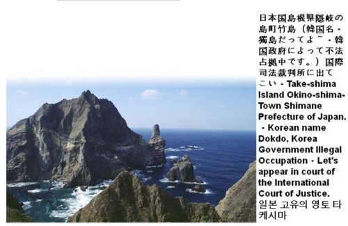
28일 새벽 한 누리꾼이 포털 커뮤니티에 "구글어스에서 독도를 찾으면 '일본 고유의 영토 다케시마'로 소개하고 있으며, '타케시마'를 한국이 불법 점유했다고 설명하고 있다"며 제보를 올렸다. 이어 이 누리꾼은 '우리가 직접 나서서 고치자'며 방법을 아는 사람은 알려 달라고 요청했다.

이에 'KOREAN'이란 닉네임의 누리꾼이 이를 수정할 수 있는 방법을 제시했다. 우선 구글 어스의 도움말 페이지(http://earth.google.com/support/bin/request.py? & problem=billing & extra.customer=GEFree & contact_type=data)에 접속한다. '한국어로는 답변해 드릴 수가 없습니다'라고 알리고 있기 때문에, 선택 가능한 언어로 '영어'를 고른다. 다음 페이지에서 'Please select the problem you're experiencing(당신이 겪고있는 문제를 고르세요)' 이라는 선택 창이 보이면 'Contains photographic errors(사진 오류)'를 선택하고 자신의 이메일 주소를 입력한 뒤 메시지 란에 아래와 같은 내용을 붙여넣으면 된다고한다.

(사진=구글어스 캡쳐)


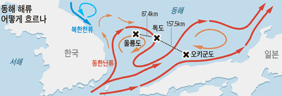
"The user uploaded photograph regarding Dokdo (독도, Dokdo-ri, Ulleung-eup, Ulleung-gun, Gyeongsangbuk-do 799-805, South Korea) contains a caption that includes information about Dokdo that is seriously BIASED and WRONG. It says "Take-shima Island Okino-shima-Town Shimane Prefecture of Japan. - Korean name Dokdo, Korea Government illegal occupation-let's appear in court of the international court of justice" in three different languages, Japanese, English and Korean. Dokdo is the easternmost territory of Korea and situated 87.4km to the southeast of Ulleungdo Island. PLEASE REMOVE THE CAPTION CONTAINING SERIOUSLY BIASED AND WRONG INFORMATION REGARDING DOKDO AS SOON AS POSSIBLE. THANK YOU."

이 메시지는 구글 어스에 나와있는 독도에 관한 설명문은 심각한 편견에 치우쳐 있고 독도는 대한민국의 영토이므로 사진의 설명문을 최대한 빠르게 삭제해 달라고 건의하고 있다.

메시지 입력 후에는 위성 사진 아래 칸에 '독도, Dokdo-ri, Ulleung-eup, Ulleung-gun, Gyungsangbuk-do 799-805, South Korea'라고 독도의 주소를 적어 넣고, 'Search(찾기)' 버튼을 클릭한 뒤 아래의 'Submit(제출)'을 누르면 구글 측에 사진 설명에 대한 수정 요청이 전달된다고 한다.

이를 접한 누리꾼들은 "구글 왜 이러나요. 얼마 전엔 대한민국을 일본으로 번역하질 않나." "이런 일이 있을 때마다 윗 사람들은 뭘 하고 네티즌들이 이렇게 나서야 하는 건지 모르겠네요"라고 분노하는 한편, "베플님이 올려주신 방법대로 구글어스로 달려가서 독도 설명을 바로잡읍시다" "구글어스 제대로 바뀔 때까지 트위터에서 무한 RT(리트윗) 합시다"라며 뜨거운 참여 의지를 보이고 있다.